
Wildfires
Water is one of Earth's most vital resources, but in many regions, water supplies are increasingly scarce. Learn how Earth data are improving monitoring and forecasting of water use, availability and water extremes.
INFO
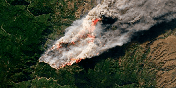
Changes in climate, weather, vegetation and the landscape all play a role in whether a spark becomes a flame. Wildfires, also referred to as wildland fires, pose threats to human safety across large geographic regions and can cause widespread health and ecological impacts. For instance, smoke from fires can impact air quality in areas across the country or even the world.
At the same time, wildfires are a natural process that maintains ecosystem stability reinforcing the need to understand the multifaceted nature of fires across the landscape. The unique vantage point offered by Earth observing satellites provides researchers and land managers with the ability to assess broadscale extents of fire related hazards that is not possible with traditional ground-based monitoring.
This information is used by agencies at multiple levels of government and management teams on the ground during all stages of wildfires, including monitoring fire prone regions, tracking and responding to active wildfires and assessing post wildfire zones.
NASA and Fire
Wildland fires, which are natural and essential for many ecosystems, have increased in frequency and size due to longer fire seasons, climate change, and the expanding interface between communities and wild vegetation. Using fire strategically—through prescribed burns and natural ignitions—can mitigate future severe fires that might burn more intensely under hotter, drier conditions.
Related Data Visualizations
Lightning Events Detected from the International Space Station (ISS) 2017-2023
The Lightning Imaging Sensor (LIS) on the International Space Station (ISS) detects lightning occurring in the Earth\u2019s tropical and mid-latitude regions. The LIS provides datasets consisting of near-real time and non-quality controlled data as well as final quality controlled datasets that are manually reviewed. This data uncovers the variability and distribution of lightning and can be used for storm detection and lightning-atmosphere interaction studies. \r\n\r\nThis visualization shows the global distribution of lightning strikes between January 2017 and July 2023 using the final quality controlled science dataset. Each data point contains the latitude and longitude of the strike as well as the time it was detected by the LIS. A roving window of 10 days was used to visualize the seasonal patterns of lightning.\n\nVisualizations by: Michala Garrison\nFor more information or to download this public domain video, go to https://svs.gsfc.nasa.gov/5011
WILDFIRE STORIES
 External Link
INTRODUCTION TO WILDFIRES
Wildfires near homes can be deadly when they are out of control, but wildfires are also key to keeping ecosystems healthy and thriving. Learn about how wildfires have intensified with a changing climate across the world and how Earth data are being used to identify, track, and monitor wildfires and their associated risks.