
Agriculture
Water is one of Earth's most vital resources, but in many regions, water supplies are increasingly scarce. Learn how Earth data are improving monitoring and forecasting of water use, availability and water extremes.
INFO
Producing food has always been challenging, and in the 21st century, human-caused climate change is already affecting food security through increasing temperatures, increased frequency of extreme events, and changing precipitation patterns.
Earth data has increasingly become part of the food farming process. Observations from satellites, aircraft, ground sensors, and surveys, combined with high-end computer modeling are used by scientists working with federal agencies who collaborate with farmers, ranchers, fishermen, and decision-makers to share their understanding of the relationship between the Earth system and the environments that provide food across the globe.
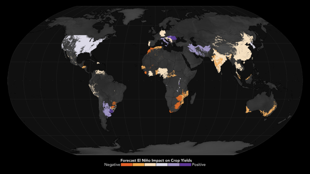
A global map forecasting the impact of El Niño on crop yields. Areas colored in shades of orange indicate regions expected to experience negative impacts on crop yields, while areas in shades of purple are expected to see positive impacts. The map highlights significant regional variations, with negative impacts forecasted for parts of South America, Southern Africa, Southeast Asia, and Australia. Conversely, positive impacts are anticipated in certain regions of North and South America, Europe, and Southwest Asia. This visualization underscores the varied effects of El Niño on agricultural productivity across different global regions.
How NASA Data Stabilizes Global Markets
NASA partners with the U.S. Department of Agriculture (USDA) to help stabilize world food markets by providing critical NASA Earth observations data that tracks global crop production, data the U.S. Department of Agriculture (USDA) uses to stabilize world food markets. Each month, this data feeds into the World Agricultural Supply and Demand Estimates (WASDE) report—an essential resource used by farmers, traders, and policymakers to forecast agricultural trends and anticipate global food supply disruptions. Using satellite observations combined with ground reports and meteorological data, NASA enables USDA analysts to monitor crops around the world across the planet—including regions that are otherwise hard to access. This global perspective helps identifiesy emerging droughts, floods, and other agricultural risks before harvest, allowing markets to respond quickly and effectively. By delivering timely, science-based insights from space, NASA supports smarter farming decisions and helps keep food prices more stable for consumers around the world. Credit: NASA/USDA
Related Data Visualizations
A 3D View of an Atmospheric River from an Earth System Model
Water vapor moves around the world as 'atmospheric rivers.' Like regular rivers, they are long and narrow and transport water. In this visualization, the blue color shows a 3-D view of water vapor leaving the tropics and traveling to the U.S. West Coast. These atmospheric rivers that begin in Hawai'i are named 'pineapple express.'